
My “Window Wanderland” display, in the three windows of an upstairs bay, as seen from the street in the dark February night – and including the unforeseen problem of condensation around the bottom of the apple tree!
This post was started not long after the first Window Wonderland event in our village in February 2017, but sat at the back of my computer unfinished until now! We’ve had two more of these events since then, more on those in a future post.
Our village held its first Window Wonderland event recently, organised by a neighbour (the idea started in Bristol and has become global now, click here to find out more); it’s a charmingly inventive way to brighten the evening streets after the glitter of Christmas has been put away and there still seems to be a long stretch of dark nights to get through before spring arrives – we couldn’t not take part! No theme was specified but I decided to use the event as an opportunity to look back at the past of our house and its surroundings – a topic I’ve always been interested in but the fascination and the urge to learn more has been growing. So I created three images for an upstairs bay window that offered a visual micro-history of our part of the village – and being a bird lover a few resident and regular visiting species appear too! So here are the multiple-layered stories behind each window.
Window 1; Bristol Channel Pilot Cutter.
 A note of excuse! I come from landlocked Hertfordshire and have no knowledge of nautical or maritime matters, but after nearly 30 years living in a village that has such long and strong connections with seafaring I’ve become absorbed by this historic and essential association; over the years I’ve enjoyed conversations with local Pilots and Hobblers (more on these in the related post here) or relatives of seafaring families in the village who have helped in my education! So I hope I will be forgiven if I’ve given inaccurate information or used the wrong terms in the following passages – this land-lubber still has much to learn! Corrections, or (polite!) comments from relatives of local families whose names appear here, are welcome via the contact page, as is other information about the pilot cutters or any other aspects of the history mentioned here.
Many of the houses in our road were built in the 1890s and local knowledge has it that the majority of them were intended for the Pill Pilots – the skilled seamen who were essential to guiding sailing ships through the treacherous waters of the Severn and up the challenging bends of the Avon into Bristol. The success and survival of the port of Bristol, and all those associated with its trade, would not have been possible without the pilots and other specialised seamen from our village. In the mid 19th century these pilots were using the fast and beautiful Bristol Channel Pilot Cutters to reach the ships out in the Bristol Channel.
But the 1890’s Pill Pilots were, it seems a rather different breed to their predecessors, especially those who’d lived in the 18th century. At that time they were self-employed, and in competition with one another; it seems they often had a tempestuous relationship with ship owners and those in positions of power in Bristol such as the Merchant Venturers. In a fascinating pamphlet Pirates to Proletarians – The Experience of the Pilots and Watermen of Crockerne Pill in the Nineteenth Century author Mike Richardson, of the Bristol Radical History Group writes that “Pill people exhibited a lack of deference and were looked upon by the Bristol authorities, and many town-dwellers, as disorderly and difficult.” In the 18thC the pilots had been associated with smuggling and in 1755 the founder of the Methodists, John Wesley wrote “I rode over to Pill, a place famous from generation to generation […] for stupid, brutal, abandoned wickedness.”
However, Mike Richardson continues, “By the 1870s it is possible to detect the emergence of a cultural demarcation in the village. Some pilot families sought respectability through the church” – this was the Methodist Church – Wesley would have been gratified at the transformation! By the 1880s with increased use of steam powered ships, the success of the railways and the rise of trade union movements, the need for greater co-operation between pilots became necessary and working practices began to change as they became part of the United Kingdom Pilots’ Association.
By the last decade of the 19th century the pilots’ status was changing and maybe there was a perception of them attaining a more ‘respectable’ place in society than their previous, somewhat maverick, reputation allowed; they became more affluent too and were looking for accommodation to match their new standing in the village.
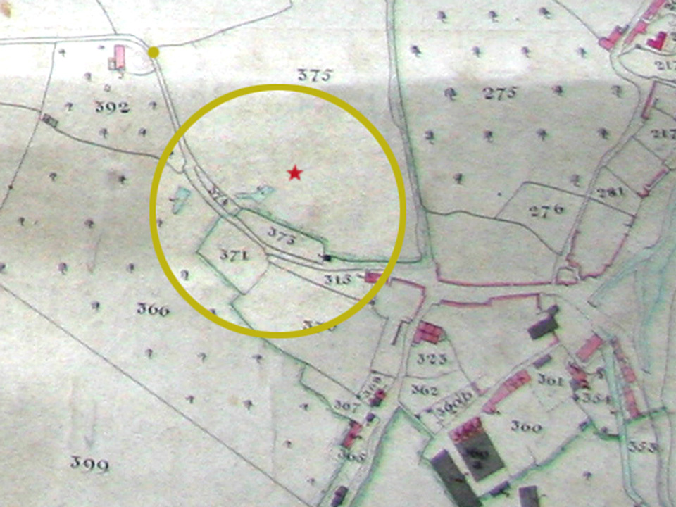
From an 1841 map of the Pill area, the red star in Plot 375 indicates where the centre of the new road of houses, Church Path Road, would be 54 years later.
So new houses were needed to meet this demand, and one site that was developed into the street of houses where I now live, was Pill Field. The 1841 Tithe map (see above) shows that this pasture of 4 acres, 3 roods and 29 perches, was once owned by James Adam Gordon, who lived in Naish House in nearby Portbury. He’d inherited this land from his father James Gordon, along with another 331 plots in the parish which amounted to nearly 70% of the land – he owned the entire hamlet of Pill. But this was not all, there was also an estate in Hertfordshire, and property in the West Indies: sugar plantations in Antigua, St Vincent and St Kitts along with 420 enslaved people. James Adam Gordon applied for compensation for the loss of his ‘property’ (the 420 people) when slaves were emancipated in 1833 as a result of the Slavery Abolition Act. He was not awarded all he applied for (there were a number of counterclaims) but he still received substantial reparations (in today’s money approximately £1.5 million) while his enslaved workers gained nothing but their very relative ‘freedom’.
Not long after Gordon died in 1854, his widow Emma Katherine (nee Wolley) married Richard Bright, 1822 – 1878. Her inheritance automatically passed to Richard until his death since married women could not legally own property in their own right until 1870. Richard was a merchant and Conservative MP for Somerset East for 10 years and the grandson of Richard Bright Senior of Ham Green House, and nephew of Dr Richard Bright and of Henry Bright.
The Bright family were renowned for their kindness and philanthropy but they too were plantation and slave owners and at one point slave traders, who also benefited from a settlement for the loss of their slaves to the present day equivalent of £600,000. More information about this local family of merchants, scientists and doctors can be found in another of my posts on Pill history, The Brights of Ham Green House – wealth and health, science and slavery. It’s very likely that Pilots from Pill would have guided the merchant ships (not slave ships) belonging to both the Gordon and Bright families into and out of Bristol harbour, and of course past Pill, on their voyages to the West Indies carrying barrels of unrefined sugar or rum from their plantations to be sold in Bristol, and returning west with cargo such as “guns, agricultural implements, foodstuffs, soap, candles, ladies’ boots and ‘Negro cloaths’ for the enslaved.” from Bristol Museums’ website.
So through his marriage to the wealthy Emma Catherine Gordon, Richard Bright became the owner of, amongst much other property, Pill field.

Plot 375, Pill field in 1877
But information from the deeds of our house suggests that 4 years before his own death in 1878 he sold part of this land to a Mr W Hall along with two gardens, reducing the area of Pill field to 3 acres and 13 perches. The plot our house was to be built on changed hands again and was sold in 1893 by Thomas Russell Kent for £100 to builder William Porter who planned to construct a ‘semi-detached villa’.

1893 and 1895 plans of new building plots along the new road, initially shown on the plan on the right as Springfield Road, the later name of Church Path Road is pencilled in below.
This was to be located on what would become a new road that followed the route of the ‘Church path’ across the fields to St George’s – Pill’s parish church until its own, Christ Church, was built in the 1860s. The road was initially identified on plans as Springfield Road but became Church Path Road not long after completion. By 1895 Mr Porter accepted £200 for the sale of the dwelling house (then known as Albany Villa, later changed to Cornwall House) from a Mrs Eliza Morris, wife of James Morris of Langford, Somerset.
Whether she (or they) bought the house to live in or to lease to others I don’t know, but the first occupiers of our house that I can find recorded are in the 1901 census; they were the family of Thomas G Hunt (whose relatives still live in the village), who was then 37 and a Master Mariner. The family were still here 10 years later by which time their 16 year old son, also Thomas, was a pilot’s apprentice.
I had a quick look at the channel pilots’ records to find the names of the vessels these two men might have commanded but only discovered a reference to the son as pilot of the SS Queen Mother from 1924 – 1960, (as a Master Mariner, I’m guessing Hunt senior was not a pilot himself – this is where my ignorance shows – clarifications welcome!) one of the first steam pilot boats, and one that replaced the beautiful rigged cutters. “… on “December 12th 1922 … the era of sailing pilot cutters came to a close, when the steam cutter Queen Mary came down channel to relieve her [the Cariad]”.
I based the image of the boat on photos of several different pilot cutters, including the Marguerite, Kindly Light and the Cariad mentioned above, so this is a kind of hybrid, but the Cariad is my favourite. Her name is welsh for ‘loved one’ and she was built in 1904 at Rowles’ boatyard here in Pill; there’s a great photo of pilot cutters in Pill creek with the boatyard in the foreground, here. From a description on the National Historic Ships website:
Her frames and beams were of oak, and the planking of her garboards and bottom to the turn of the bilge was elm; above that it was pitch pine. The keel was of elm and she was fastened with galvanised iron. The mast, boom and bowsprit were of pitch pine, with gaff and squaresail yard of fir. Rowles started building cutters at Pill in 1887 and continued until 1910. He had the reputation for building fast and elegant looking boats, and CARIAD, no exception, had his cutters’ characteristic elliptical contour.
After various alterations and refurbishments, she survives to this day and is based in Swansea.
In this window picture a few Swifts accompany the Pilot cutter – they are regular summer visitors to the air above our road and, along with House Martins are often seen half a mile away down by the Avon and Pill creek (birth/berth-place of the Cariad) where the Martins scoop up the mud from the river bank to build their nests under the eaves of the Duke of Cornwall pub (see photos below). I expect both species have been coming here since long before John Cabot sailed past Pill from Bristol in the Matthew in 1497 bound for unknown western shores, guided into the Bristol Channel (allegedly) by Pill pilot James George Ray.

Swift above Church Path Road cable clutter

Young House Martins in their nest of mud scooped from the banks of the River Avon at low tide, under the eaves of the Duke of Cornwall pub, next to Pill creek.
Window 2; the Bull.
 A visit to the Know Your Place website (where you can view comparative maps of a location in different eras) gives a clear idea of the impact our houses made on what was Pill Field, owned in 1841 by James Adam Gordon, as mentioned above, but leased to George Wilkins who in turn sublet this pasture land to Samuel Bryant, so the field would have been grazed by cattle or sheep.
The southern boundary of the field was Bull Lane that runs along what later became the end of the gardens of Church Path Road, flanked in places by a steep bank. It’s a deep, curved, sunken lane that slopes down towards the village centre. It seems very likely that this was a very old drove road (hence the name) where cattle would have been driven from the higher fields at the south and west of Pill and the adjoining Easton-in-Gordano, to graze by the river, or to be taken to the slaughterhouse in Back Lane on the hill above the creek in the village.
The bull image is from an 18th Century woodblock illustration. The owl and the moon are a wishful visual conjunction but from our garden in the summer the full moon comes up from behind Bull Lane and we often hear owls calling nearby – there would have been many more when this area was still fields providing an abundant food supply of small rodents for the owls.
Window 3, centre of bay; Apple Tree
 When I first heard about the Window Wonderland project an image of a stylised apple tree lit up in the window, popped spontaneously into my head! That was before I’d thought about linking the images with local history. However, the apple tree stuck and the ideas for the other two themes and images described above just fell into place. Unlike the other two images that are based on photographs and other people’s illustrations, this is a hand-cut stencil from my own drawing. This picture is partly in recognition of the importance of the large number of orchards in the area but also a celebration of our wonderful Community Orchard that I can just see from our house.
It’s on top of Watchhouse Hill that overlooks the village from the other side of Pill Creek and was planted in the late 1940s to provide fruit for the TB and isolation hospital at Ham Green. It contained a wide variety of eating and cooking apples, pears, cherries, plums and greengages; there was a farm attached to the hospital too. More on the history of this orchard and its surrounding area can be found in two of my other posts here, and here. There are no orchards in Pill now but there were once dozens in and around our neighbouring villages of Pill, Ham Green and Easton-in-Gordano that survived up to the 1960s I believe; go to Know Your Place North Somerset, search for the names of any of the villages then select a map from the 19th century and you’ll see the extent of the orchards, especially to the west.
Directly behind where our house was built, on the other side of Bull Lane from Pill Field were several orchards. In 1841 these were owned by the same Gordon James Adam as the Pill Field, but were leased to and occupied by Samuel Vowles. There was a well known smallholding called Willmotts at the village end of our road that still appears on the 1943 OS map.
Whether the orchards were mostly apples or included plums, cherries or other fruit, I don’t know but until last year there was a Damson tree down by the River Avon that may have been a remnant of the orchards that grew along banks of the Avon in the Longshore area. It was next to a well-used footpath but became a bit large and straggly so someone saw fit to cut it down.
I’m also uncertain about the types of apples that were grown – eating, cooking or cider apples but round the corner from our road is a cul-de-sac of 1970s houses built on the site of an orchard and named Bramley Close, which at least offers a clue to the production there of cooking apples. And where did all this fruit go when it was ripe? Into the village shops or off on the railway into Bristol or Portishead? To local cider makers? I’d be pleased to hear of any information about this, send a message via my contact page.
And finally, the bird motif in this window is the silhouette of a single Fieldfare flying in front of the tree; rarely seen on their own but time ran out before I could cut out a whole flock! Along with their cousins the Redwings, they are regular winter visitors to the orchard and watching them feasting on the fallen apples, especially when there’s snow on the ground, is a small pleasure for me.

Fieldfares foraging for fallen apples in the snow in Pill Community Orchard.
Sources of information used for this post:
- The Bristol Pilots, John Rich
- Pirates to Proletarians – The Experience of the Pilots and Watermen of Crockerne Pill in the Nineteenth Century, author Mike Richardson
- Notes on Pill Parish website
- North Somerset Know Your Place maps
- National Historic Ships website
- Bristol Channel Pilot Cutters Owners Association
- Bristol Museums website – Transatlantic Slave Trade
- Legacies of British Slave Ownership website
- House deeds – personal documents
All photographs in this post, and photographs of diagrams and plans from house deeds are my own; other images used in the making of the window displays, or of old maps were from out of copyright sources, or from copyright-free sites on the internet.

Hello Maureen, There’s a list of pilots names going back a long time in John Rich’s book The Bristol Pilots.
LikeLike
Do you have the names of the pilot men from 1880s
LikeLike
Hello Mike, I do apologise, I’ve only just seen your comment! I was also given your name and phone number by Garfield Porter as he told me that you knew about the orchards in Pill but I’ve been a bit busy with other projects. Yes, I’d love to hear your memories about Bramley Close Orchard – would you like to add them to another comment on here, or e-mail them to me ( liz.milner.work.projects@gmail.com ), or chat over the phone? Apologies again for such a slow reply! Liz Milner.
LikeLike
Are you still seeking comments on “Bramley Close ” orchard . I picked fruit there in youth
LikeLike
Glad you found it of interest Liz. Not sure about a book!!!
LikeLike
Thank you for sharing this Liz. There’s so much info, some stuff I hadn’t heard before so I’m saving it all for future reference. That’s a great title – I’m looking forward to the book! Liz (Moore)
Sent from Mail for Windows 10
LikeLike